This will be helpful to a lot of communities suffering hardship due to Novel Coronavirus COVID-19!
Wild Open Eye - Natural Vision, News from Wild Open Eye
Is your community reliant on wildlife tourism impacted by COVID-19?
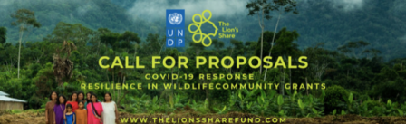
The Lion’s Share is currently considering proposals between USD $20,000 and $50,000 focused on strengthening resiliency in communities reliant on wildlife-based ecotourism. The deadline to submit your proposal is 5 pm (EST)May 15, 2020. UNDP Lion’s Share programme encourages any interested non-profit organization to submit the following proposal!
The PDF below has information about this opportunity and below that is a pdf of the application form. Good luck and God bless you all!
As of April 14, 2020, over 1.8 million people worldwide have contracted the novel coronavirus, COVID-19. The spread of COVID-19 is a health crisis but it is not just a health crisis. COVID-19 threatens to create devastating social, economic, and political crises that could leave…
View original post 645 more words